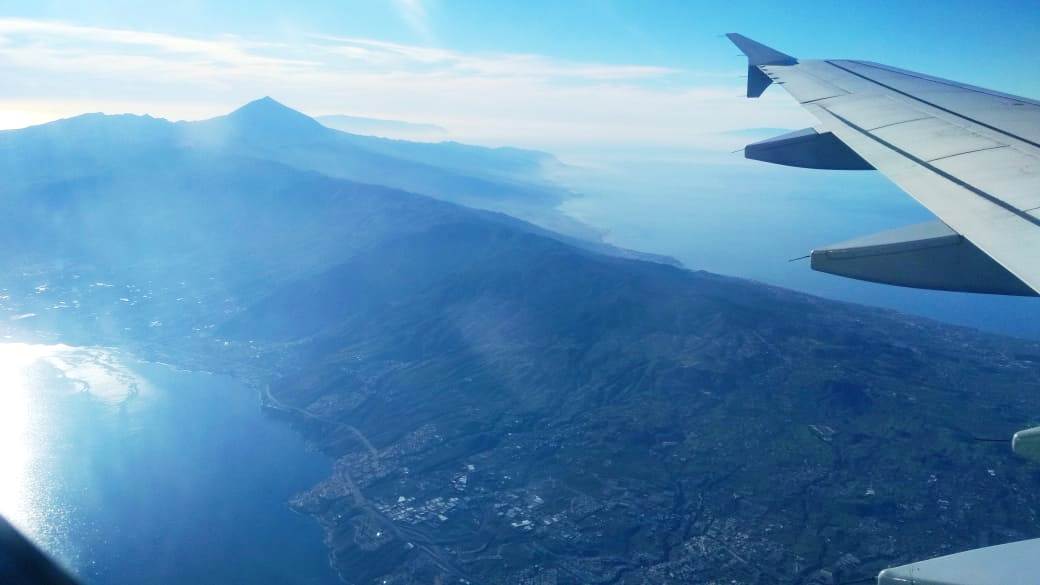
TENERIFE
La isla de los exploradores y jubilados

Turística, geográfica y geológica, Tenerife se puede dividir en 5 áreas principales:
Las montañas de Teno en el oeste (rojo) - Las montañas de Anaga en el este (negro) - El norte verde - El área central del Teide - y el "resto espeluznante", dice: los castillos turísticos al oeste y al sur, con La playa de Medano como Windsurfer / kite center.
MOVERSE
¡Se recomienda ENCARECIDAMENTE UN COCHE DE ALQUILER para quienes llegan del aeropuerto y visitan las islas!
Buena empresa de alquiler de coches: autoreisen.com
El sistema de autobuses está bastante desarrollado, pero la siguiente parada está a 1,8 km de mi finca, ¡con un desnivel de 200 m!
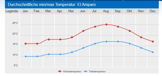
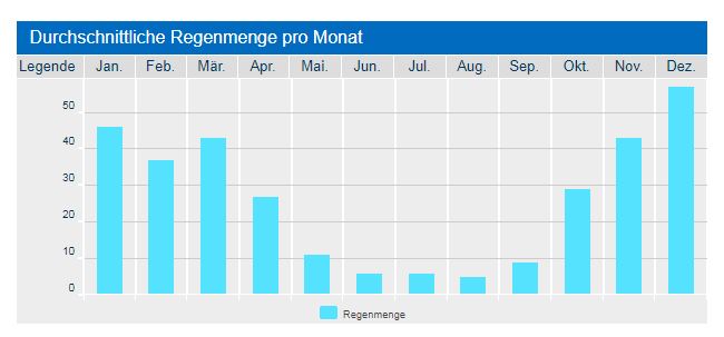
El Clima
¡El clima en Tenerife varía mucho! La costa sur es más cálida y la norte más fresca y húmeda.
Además, ... dependiendo de la altitud hace más frío! No olvides! en promedio, que cada 100 m de altura - ¡1 grado de temperatura!
Mi finca en 625 m de altitud es siempre 6,5 grados ENFRIADOR en comperación hacia al Mar y mucho más húmeda!
Véase las tablas de clima en "El Amparo" - todavía está a 150 m "debajo de" mi Finca
Coordenadas Útiles
Costa Norte
Socorro Beach und Cafe
https://goo.gl/maps/vymSs6jJwDR2
Pool ("Lago Martianez") in Puerto Cruz
https://goo.gl/maps/UdKPw6hPmkF2
Garachico Beach
https://goo.gl/maps/2788NtLo2r52
San Marocs Beach
https://goo.gl/maps/Rf4P9mVXSfD2
Nice Fish Resaurant close to the Ocean
https://goo.gl/maps/Tr6uGW2F6Ju
Picknick Area Arenas Negras:
https://goo.gl/maps/jAnz8ewv4aN2
..and the Chinyero
https://goo.gl/maps/f9t9y32DCip
Ausflugziel auf dem Weg zu Teide, "Caldera"
https://goo.gl/maps/ufNnBAv8z2B2
Costa Este y Oeste:
Masca
https://goo.gl/maps/qhrotJK6Szx
Anaga Mountain
https://goo.gl/maps/rxxjLyZwvtk
Supermercados:
El Amparo (most close my Finca)
https://goo.gl/maps/WE3mJH5pFjo
Icod:
Mercadona und Hiperdino in Icod
https://goo.gl/maps/8f7Ccy9ZGb92
Lidl Realejos
https://goo.gl/maps/3tttBH4yUr42
Lidl Puerto Cruz
https://goo.gl/maps/bD7hRXmdqFn
Einkaufszentrum Puerto (Nähe Lidl)
https://goo.gl/maps/GQX1suR15i72
Car Rental:
autoreisen.com
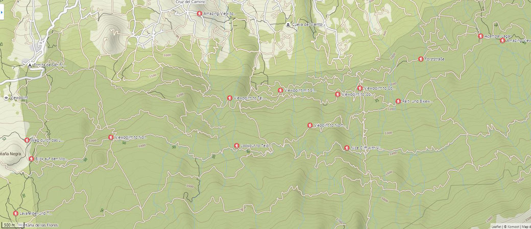
SENDEROS y CAMINATAS
Se recomienda para el senderismo. ¡Utiliza una aplicación de senderismo! Yo uso la aplicación "Komoot"! (Dt y En): https://www.komoot.com/discover
Ahí guardé muchas visitas públicas! Caminos que ni siquiera están en las cartas y agradables viajes de ida y vuelta, en el área de mi finca. Mi nick es "mchaco"
Here some nice links for walks:
a short 3,5 km evening walk : https://www.komoot.com/tour/54347143?ref=wtd
A nice 5km roundwalk from teh cave around my finca: https://www.komoot.com/tour/54347002?ref=wtd
My "new" 5.5 km Eve Walk: https://www.komoot.com/tour/55640138?ref=wtd
My Standard 6.5 km Walk: https://www.komoot.com/tour/55854946?ref=wtd
Just another 6.5 km: https://www.komoot.com/tour/55640094?ref=wtd
8,5 km around the Cave : https://www.komoot.com/tour/54340740?ref=wtd-m
desde mi Casa to the neighboring village (Cruce los caminos) and back: https://www.komoot.com/tour/54820486?ref=wtd
desde mi Casa New 8.5 km loopwalk : https://www.komoot.de/tour/106179430?ref=wtd
desde mi Casa 9 km Round Hike 650 m up: https://www.komoot.de/tour/104381700?ref=wtd
desde mi Casa: 15 km (750 m slope) "Teide Test walk": https://www.komoot.de/tour/56899658?ref=wtd
Nice 6.5 km round walk above Montañeta: https://www.komoot.de/tour/95771045?ref=wtd
A 12 km walk : https://www.komoot.com/tour/55696488?ref=wtd
Up to the Icod Viewpoint: https://www.komoot.com/tour/52493368?ref=wtd
7 km nice roundwalk: https://www.komoot.com/tour/51789872?ref=wtd
The ancient Guanche trek: https://www.komoot.com/tour/55485201?ref=wtd
The connection path between 3.to .th line : https://www.komoot.com/tour/55225403?ref=wtd
My favorite Walk in AGUAMANSA (Orotava Valley): https://www.komoot.de/tour/46696533?ref=wtd
A quite nice 9 km roundwalk in Arenas Negras: https://www.komoot.com/tour/52991328?ref=wtd
A Walk around Montana Negra: https://www.komoot.com/tour/39300251?ref=wtd
The Chinyero Walk: https://www.komoot.com/tour/28345491?ref=wtd: